Datei:Emi Koussi Volcano and Aorounga Impact Crater, Chad (enhanced).jpg
Aus Klexikon – das Kinderlexikon
Größe dieser Vorschau: 800 × 531 Pixel. Weitere Auflösungen: 320 × 213 Pixel | 640 × 425 Pixel | 1.024 × 680 Pixel | 1.280 × 850 Pixel | 2.560 × 1.700 Pixel | 4.288 × 2.848 Pixel.
Originaldatei (4.288 × 2.848 Pixel, Dateigröße: 2,5 MB, MIME-Typ: image/jpeg)
Beschreibung
| Beschreibung |
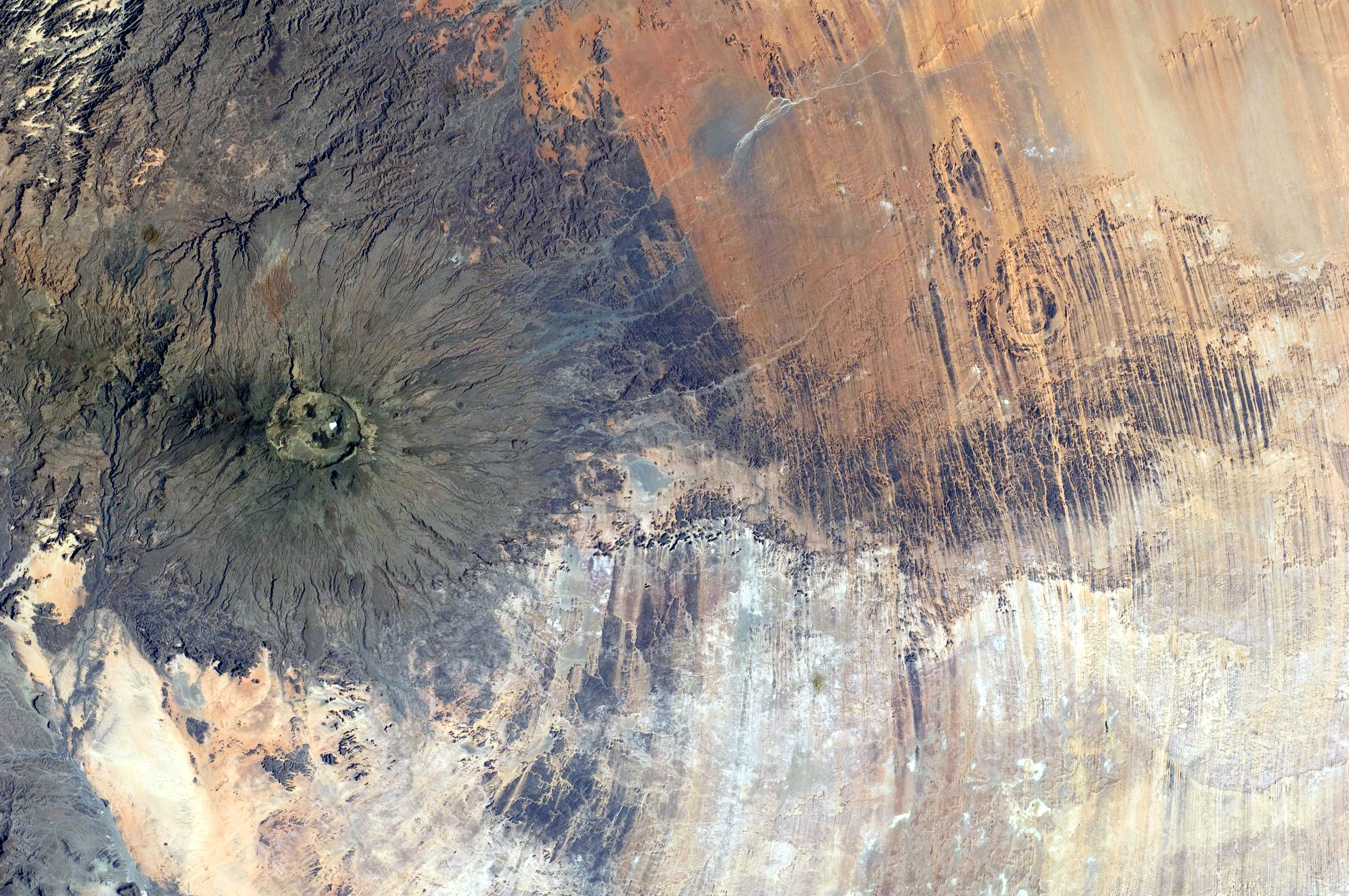
English: Emi Koussi Volcano and Aorounga Impact Crater, Chad are featured in this image photographed by an Expedition 30 crew member on the International Space Station.
|
||||||||||||||||||||||||||||||||||||||||||||||||
| Datum | |||||||||||||||||||||||||||||||||||||||||||||||||
| Quelle | Spaceflight.NASA.gov: ISS030-E-005456 | ||||||||||||||||||||||||||||||||||||||||||||||||
| Urheber | NASA | ||||||||||||||||||||||||||||||||||||||||||||||||
| Andere Versionen |
|
||||||||||||||||||||||||||||||||||||||||||||||||


| Objektposition | | Dieses und weitere Bilder auf OpenStreetMap |
|---|
| Kameraposition | | Dieses und weitere Bilder auf OpenStreetMap |
|---|
| Dieses Bild wurde digital nachbearbeitet. Folgende Änderungen wurden vorgenommen: Removed color cast. Bearbeitet von FerJox.
|
Diese Mediendatei wurde vom Johnson Space Center der US-amerikanischen National Aeronautics and Space Administration (NASA) unter der Datei-ID ISS030-E-005456 kategorisiert. Diese Markierung zeigt nicht den Urheberrechtsstatus des zugehörigen Werks an. Es ist in jedem Falle zusätzlich eine normale Lizenzvorlage erforderlich. Siehe Commons:Lizenzen für weitere Informationen. Sprachen:
|
Lizenz
Diese Datei ist gemeinfrei (public domain), da sie vom Image Science & Analysis Laboratory der NASA erstellt worden ist. Die NASA-Urheberrechtsrichtlinie besagt, dass „NASA-Material nicht durch Urheberrecht geschützt ist, wenn es nicht anders angegeben ist“ (NASA-Urheberrechtsrichtlinien-Seite oder Nutzungsbedingungen für Fotos von Astronauten). Die Aufnahme ist Teil der Reihe The Gateway to Astronaut Photography of Earth. Bildquelle: ISS030-E-5456.
|
Dateiversionen
Klicke auf einen Zeitpunkt, um diese Version zu laden.
| Version vom | Vorschaubild | Maße | Benutzer | Kommentar | |
|---|---|---|---|---|---|
| aktuell | 22:22, 26. Jun. 2019 | | 4.288 × 2.848 (2,5 MB) | wikimediacommons>FerJox | User created page with UploadWizard |
Dateiverwendung
Die folgende Seite verwendet diese Datei:


.jpg¶ms=019.500000_N_0018.500000_E_globe:Earth_class:object_type:object__&language=de)
.jpg¶ms=019.600000_N_0019.800000_E_globe:Earth_type:camera__&language=de)
.jpg)
.jpg)
.jpg&action=edit&redlink=1)
.jpg)
.jpg)
.jpg&action=info)