Datei:ISS046-E-3699.JPG

Originaldatei (4.928 × 3.280 Pixel, Dateigröße: 2,49 MB, MIME-Typ: image/jpeg)
Beschreibung
| Beschreibung |
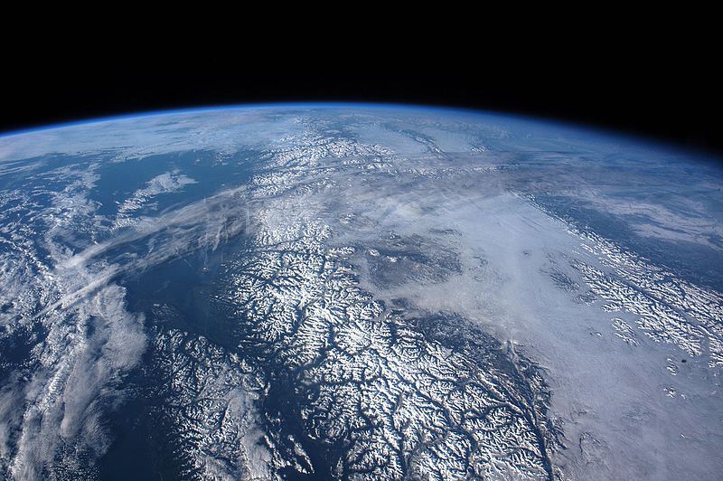
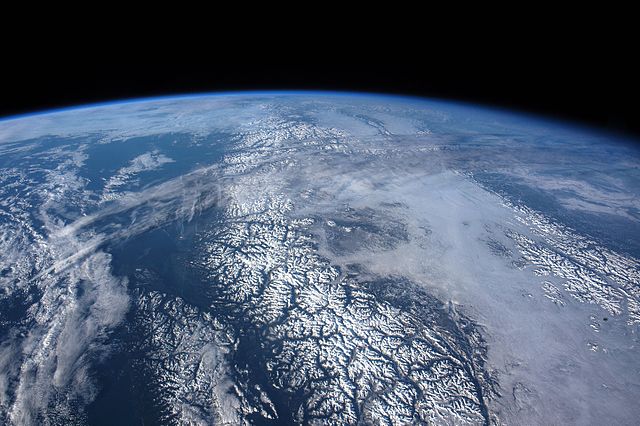
English: While orbiting over the Gulf of Alaska and moving toward the west coast of the United States, an astronaut aboard the International Space Station shot this panorama looking north into the snow-covered landscape of Canada’s Coast Mountains, the Canadian Rockies, and Vancouver Island. Numerous dark valleys contrast with the brilliant snow, even in the low light of a northern winter. The valleys were eroded by glaciers repeatedly in various ice ages over the past 2 to 3 million years.
Low stratus clouds mask the 250-kilometer (150-mile) wide plateau between the mountain ranges. Above these clouds, a long cloud band slants across the image. Meteorologists think this may be the remnants of a jet stream cloud band. Such jet stream bands indicate the general position of these fast “rivers of air.” Based on its northeast orientation, its altitude, and its linear appearance, the cloud band is in the typical position and orientation of the Polar Jet, which blows northeast towards Hudson Bay, then dives south over the southeastern provinces of Canada. Animated maps of the Polar Jet for the days before this image show a dying branch of the jet over western Canada. Even in this distant view, several thin contrails appear, disrupting the jet band and showing where aircraft flew in and near the jet stream. Aircraft take advantage of these fast jets (which can reach speeds of more than 440 kilometers or 275 miles per hour) as tail winds that can shorten flight times.Français : Alors en orbite au-dessus du golfe de l'Alaska et se dirigeant vers la côte ouest des États-Unis, un astronaute à bord de la Station spatiale internationale a photographié ce panorama face au nord, les montagnes côtières couvertes de neige, des Rocheuses canadiennes et de l'île de Vancouver. De nombreuses vallées sombres contrastent avec la neige brillante, même à la faible lumière d'un hiver nordique. Les vallées ont été érodées par les glaciers à plusieurs reprises au cours des différents âges glaciaires des 2 à 3 millions d'années passées.
Les nuages de stratus masquent le plateau large de 250 kilomètres entre les chaînes de montagnes. Au-dessus de ces nuages, une longue bande de nuages flotte au travers de l'image. Les météorologues pensent que ce peut être les restes d'une bande nuage d'un courant-jet. En raison de son orientation nord-est, de son altitude et de son aspect linéaire, la bande de nuages se trouve dans la position et l'orientation typiques du jet polaire qui souffle vers le nord-est de la Baie d'Hudson, puis plonge vers le sud sur les provinces du sud-est du Canada. Les cartes animées du Jet Polaire des jours précédant cette image, montrent une branche mourante du jet sur l'ouest du Canada. Même par cette vue lointaine, plusieurs traînées minces apparaissent, perturbant la bande du jet et montre où l'avion a volé, près du courant de jet. L'avion profite de ces jets (qui peuvent atteindre des vitesses de plus de 440 kilomètres à l'heure) que les vents de queue raccourcissent les temps de vol. |
| Datum | |
| Quelle | Astronaut photography of Earth |
| Urheber | Image courtesy of the Earth Science and Remote Sensing Unit, NASA Johnson Space Center |
|
Dieses Bild war am 16. Februar 2016 das Bild des Tages. Es hatte die folgende Beschreibung: English: While orbiting over the Gulf of Alaska and moving toward the west coast of the United States, an astronaut aboard the International Space Station shot this panorama looking north into the snow-covered landscape of Canada’s Coast Mountains, the Canadian Rockies, and Vancouver Island. Andere Sprachen:
Čeština: Snímek pořízený z Mezinárodní vesmírné stanice (ISS) - sněhem pokryté kanadské pobřežní hory a ostrov Vancouver. English: While orbiting over the Gulf of Alaska and moving toward the west coast of the United States, an astronaut aboard the International Space Station shot this panorama looking north into the snow-covered landscape of Canada’s Coast Mountains, the Canadian Rockies, and Vancouver Island. Español: Vista satelital, desde la Estación Espacial Internacional, del paisaje nevado de la cadena de las montañas costeras de Canadá, las Montañas Rocosas de Canadá, y la isla de Vancouver. Magyar: Az Alaszkai-öböl felől az Egyesült Államok nyugati partja felé tartó Nemzetközi Űrállomás fedélzetéről készült kép észak felé a hóval borított kanadai Sziklás-hegységről és a Vancouver-szigetről Português: Orbitando sobre o Golfo do Alasca, em direção à Costa Oeste dos Estados Unidos, um astronauta a bordo da Estação Espacial Internacional tirou este panorama olhando para o norte em direção à paisagem coberta de neve das montanhas da costa do Canadá (centro da imagem), as Montanhas Rochosas canadenses (extrema direita) e a Ilha Vancouver (inferior esquerdo). Македонски: Поглед на Канада од Меѓународната вселенска станица. 한국어: 알래스카만 상공에서 미국 서해안으로 비행하던 중에 국제우주정거장에 탑승한 우주비행사가 북쪽으로 눈 덮인 캐나다의 산악, 캐나다 로키 산맥과 밴쿠버 섬을 들여다보면서 찍은 풍경. 中文: 从阿拉斯加湾上空航行到美国西岸途中,国际太空站的太空人照了这张往北向看着白雪覆盖的加拿大海岸山地、洛矶山脉、温哥华岛全景图。 中文(繁體): 從阿拉斯加灣上空航行到美國西岸途中,國際太空站的太空人照了這張往北向看著白雪覆蓋的加拿大海岸山地、洛磯山脈、溫哥華島全景圖。 |
| Kameraposition | | Dieses und weitere Bilder auf OpenStreetMap |
|---|
Diese Mediendatei wurde vom Johnson Space Center der US-amerikanischen National Aeronautics and Space Administration (NASA) unter der Datei-ID ISS046-E-3699 kategorisiert. Diese Markierung zeigt nicht den Urheberrechtsstatus des zugehörigen Werks an. Es ist in jedem Falle zusätzlich eine normale Lizenzvorlage erforderlich. Siehe Commons:Lizenzen für weitere Informationen. Sprachen:
|
Lizenz
| Diese Datei ist gemeinfrei (public domain), da sie von der NASA erstellt worden ist. Die NASA-Urheberrechtsrichtlinie besagt, dass „NASA-Material nicht durch Urheberrecht geschützt ist, wenn es nicht anders angegeben ist“. (NASA-Urheberrechtsrichtlinie-Seite oder JPL Image Use Policy). | ||
 |
Warnung:
|
Dateiversionen
Klicke auf einen Zeitpunkt, um diese Version zu laden.
| Version vom | Vorschaubild | Maße | Benutzer | Kommentar | |
|---|---|---|---|---|---|
| aktuell | 09:33, 25. Jan. 2016 | | 4.928 × 3.280 (2,49 MB) | wikimediacommons>Originalwana | {{Information |Description ={{en|1=While orbiting over the Gulf of Alaska and moving toward the west coast of the United States, an astronaut aboard the International Space Station shot this panorama looking north into the snow-covered landscape of... |
Dateiverwendung
Die folgende Seite verwendet diese Datei:


